IMAGES TAKEN NEAR TO
East Street, OLNEY, MK46 4DW
Introduction
This page details the photographs taken nearby to East Street, MK46 4DW by members of the Geograph project.
The Geograph project started in 2005 with the aim of publishing, organising and preserving representative images for every square kilometre of Great Britain, Ireland and the Isle of Man.

There are currently over 7.5m images from over14,400 individuals and you can help contribute to the project by visiting https://www.geograph.org.uk
Image Map
Images are licensed for reuse under creativecommons.org/licenses/by-sa/2.0
Notes
- Clicking on the map will re-center to the selected point.
- The higher the marker number, the further away the image location is from the centre of the postcode.
Image Listing (109 Images Found)
Images are licensed for reuse under creativecommons.org/licenses/by-sa/2.0
Image
Details
Distance
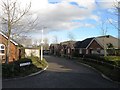
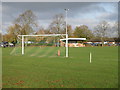
1
East Street - Olney Town Football Club
Olney are in green and playing league leaders Potton Town. All equipment including goals, flags and ropes have to be set up and taken down on matchdays. Note the parish church in the background.
Image: © nick macneill
Taken: 4 May 2004
0.04 miles
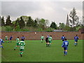
2
Olney Town Football Club
A multi sports location with football, rugby, tennis and children's play area all available.
Image: © Michael Trolove
Taken: 22 Feb 2009
0.06 miles
3
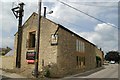
Olney old fire station
Olney old fire station, East Street, Olney, Buckinghamshire, has now been converted into a dwelling. The pole with framing on top in the foreground housed the siren for alerting the fire crew
Image: © Kevin Hale
Taken: 30 Jun 2010
0.07 miles
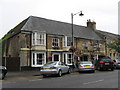
5

East Street development opportunity
The For Sale boards are up, so the end is in sight for some corrugated sheds that will be soon forgotten.
Image: © Michael Trolove
Taken: 11 Oct 2009
0.08 miles
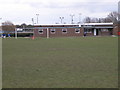
6
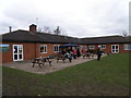
Olney Rugby Club House
Its February and the BBQ is up and running knocking out bacon butties for hungry players and spectators.
Image: © Michael Trolove
Taken: 22 Feb 2009
0.09 miles
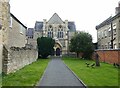
7
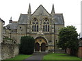
Cowper Memorial Church, Olney
The first Independent Church, as it was then called, was erected on the site in 1662, re-established in 1762, enlarged in 1818, and pulled down in 1879. The cornerstone of the present church was laid on Thursday May 2nd 1879 and opened to public worship on Tuesday June 8th 1880. At the time the church was known as the Congregational Chapel. The church was named the Cowper Memorial after one of the deacons read a brief history of the church from 1662. He said "It is 79 years since Cowper had left this mundane world to grace the higher and the eternal, to take the golden harp that is strung and tuned for endless years. Surely it is time that something was erected to his memory, something that was worthy of the man, worthy of the town, worthy of the nation and what better than a place of worship! What better than a Congregational Church."
http://www.cowperurc.org.uk/
Image: © Richard Rogerson
Taken: 21 Jul 2009
0.10 miles
9
Cowper Memorial United Reformed Church
Designed by John Sulman https://en.wikipedia.org/wiki/John_Sulman 1879-80.
Image: © Jonathan Thacker
Taken: 17 Aug 2023
0.11 miles