IMAGES TAKEN NEAR TO
Lavendon Road, OLNEY, MK46 4DF
Introduction
This page details the photographs taken nearby to Lavendon Road, MK46 4DF by members of the Geograph project.
The Geograph project started in 2005 with the aim of publishing, organising and preserving representative images for every square kilometre of Great Britain, Ireland and the Isle of Man.

There are currently over 7.5m images from over14,400 individuals and you can help contribute to the project by visiting https://www.geograph.org.uk
Image Map
Images are licensed for reuse under creativecommons.org/licenses/by-sa/2.0
Notes
- Clicking on the map will re-center to the selected point.
- The higher the marker number, the further away the image location is from the centre of the postcode.
Image Listing (3 Images Found)
Images are licensed for reuse under creativecommons.org/licenses/by-sa/2.0
Image
Details
Distance
1
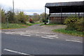
Three Shires Way going down to Lavendon Mill
Image: © Philip Jeffrey
Taken: 17 Nov 2012
0.01 miles
2
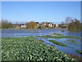
Lavendon Mill in Flood
This view facing north shows Lavendon Mill (on the left) in flood from the River Great Ouse. The Three Shires bridleway in the foreground leads from Clifton Reynes (behind camera) across the river and through the Mill grounds to Lavendon - but not on this occasion!
Image: © Nigel Stickells
Taken: 26 Nov 2006
0.02 miles
3
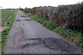
Three Shires Way on the lane to Lavendon Grange
Image: © Philip Jeffrey
Taken: 17 Nov 2012
0.13 miles