IMAGES TAKEN NEAR TO
Sanderson Close, BEDFORD, MK45 5JP
Introduction
This page details the photographs taken nearby to Sanderson Close, MK45 5JP by members of the Geograph project.
The Geograph project started in 2005 with the aim of publishing, organising and preserving representative images for every square kilometre of Great Britain, Ireland and the Isle of Man.

There are currently over 7.5m images from over14,400 individuals and you can help contribute to the project by visiting https://www.geograph.org.uk
Image Map
Images are licensed for reuse under creativecommons.org/licenses/by-sa/2.0
Notes
- Clicking on the map will re-center to the selected point.
- The higher the marker number, the further away the image location is from the centre of the postcode.
Image Listing (38 Images Found)
Images are licensed for reuse under creativecommons.org/licenses/by-sa/2.0
Image
Details
Distance
4
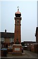
Westoning : The Clock Tower
This Clock Tower is well endowed with informative tablets and plaques. It was originally erected by "J.G. Coventry Campion and his wife" (though I doubt that they personally laid the bricks) to commemorate the Diamond Jubilee of Queen Victoria in 1897. It was renovated in both 1975 and 2003 the latter perhaps to mark 50 years since Queen Elizabeth II's coronation.
Image: © Rob Farrow
Taken: 1 Feb 2006
0.05 miles
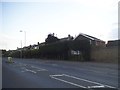
6
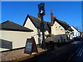
Westoning: The Chequers public house
The Chequers http://www.thechequers.com/ is a 17th century thatched public house and restaurant at the main crossroads in Westoning. The A5120 passes from left to right in the photo, changing from Park Road to the High Street as it crosses the junction with Church Road, which is to the right in the photo. The yellow painted box junction indicates that traffic can get busier...
Image: © Nigel Cox
Taken: 30 Jun 2008
0.05 miles
7
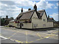
The Chequers pub, Westoning
Built in C17 and C18. See http://www.britishlistedbuildings.co.uk/en-420478-the-chequers-inn-westoning-#.VZGbwPlViko for entry in British Listed Buildings.
Image: © Bikeboy
Taken: 27 Jun 2015
0.06 miles
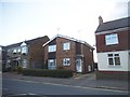
8
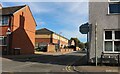
Sampshill Road, Westoning
From Park Road
Image: © David Howard
Taken: 9 Oct 2022
0.06 miles
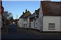
9

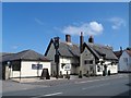
Park Road, Westoning
Looking towards The Chequers pub (not the only one in the area).
Image: © David Howard
Taken: 28 Jul 2016
0.06 miles