IMAGES TAKEN NEAR TO
Greenfield Road, BEDFORD, MK45 5FD
Introduction
This page details the photographs taken nearby to Greenfield Road, MK45 5FD by members of the Geograph project.
The Geograph project started in 2005 with the aim of publishing, organising and preserving representative images for every square kilometre of Great Britain, Ireland and the Isle of Man.

There are currently over 7.5m images from over14,400 individuals and you can help contribute to the project by visiting https://www.geograph.org.uk
Image Map
Images are licensed for reuse under creativecommons.org/licenses/by-sa/2.0
Notes
- Clicking on the map will re-center to the selected point.
- The higher the marker number, the further away the image location is from the centre of the postcode.
Image Listing (40 Images Found)
Images are licensed for reuse under creativecommons.org/licenses/by-sa/2.0
Image
Details
Distance
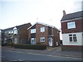
1
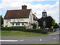
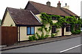
Westoning: The Bell public house
Old maps show that the 17th century Bell used to be on the main road going north out of Westoning towards Flitwick. However the modern re-alignment of the High Street has meant that it now fronts onto Greenfield Road. It is a Greene King outlet.
Image: © Nigel Cox
Taken: 30 Jun 2008
0.03 miles
3
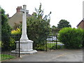
Westoning: The War Memorial
Westoning's War Memorial is at the junction of Greenfield Road with the High Street.
Image: © Nigel Cox
Taken: 30 Jun 2008
0.05 miles
4
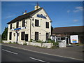
Westoning: The Nags Head public house (disused)
Photographed for posteriority The Nags Head on Greenfield Road was the third of Westoning's pubs, the others being Image and Image It has recently closed and the site is now the subject of a planning application for new housing. The pub is certainly shown on the Ordnance Survey's map edition of 1882, but just why it was built in the first place and then how it survived for so long on the edge of the village with few houses in the immediate vicinity, and with competition from the others, is a mystery. The Charles Wells Brewery of Bedford were the former owners.
Image: © Nigel Cox
Taken: 30 Jun 2008
0.07 miles
5
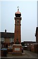
Westoning : The Clock Tower
This Clock Tower is well endowed with informative tablets and plaques. It was originally erected by "J.G. Coventry Campion and his wife" (though I doubt that they personally laid the bricks) to commemorate the Diamond Jubilee of Queen Victoria in 1897. It was renovated in both 1975 and 2003 the latter perhaps to mark 50 years since Queen Elizabeth II's coronation.
Image: © Rob Farrow
Taken: 1 Feb 2006
0.09 miles
6
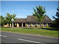
Westoning Baptist Church
The Church was built in 1989 on this site on the east side of Greenfield Road.
Image: © Nigel Cox
Taken: 30 Jun 2008
0.09 miles
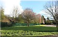
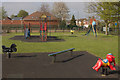
10
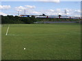
Westoning Playing Field
Westoning Playing Field with the main line on the embankment behind
Image: © Shaun Ferguson
Taken: 14 Jul 2009
0.12 miles