IMAGES TAKEN NEAR TO
Highfield Road, BEDFORD, MK45 5EB
Introduction
This page details the photographs taken nearby to Highfield Road, MK45 5EB by members of the Geograph project.
The Geograph project started in 2005 with the aim of publishing, organising and preserving representative images for every square kilometre of Great Britain, Ireland and the Isle of Man.

There are currently over 7.5m images from over14,400 individuals and you can help contribute to the project by visiting https://www.geograph.org.uk
Image Map
Images are licensed for reuse under creativecommons.org/licenses/by-sa/2.0
Notes
- Clicking on the map will re-center to the selected point.
- The higher the marker number, the further away the image location is from the centre of the postcode.
Image Listing (11 Images Found)
Images are licensed for reuse under creativecommons.org/licenses/by-sa/2.0
Image
Details
Distance
4

Flitton cemetery
Cemetery set away from the church in Flitton
Image: © Barry Ephgrave
Taken: 4 Sep 2010
0.20 miles

9

Bench
No dedication just a bench to rest your legs
Image: © Barry Ephgrave
Taken: 4 Sep 2010
0.24 miles
10
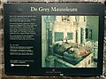
De Grey Mausoleum sign
This sign gives information about the De Grey Mausoleum which is attached to Image] and is cared for by English Heritage. When I visited I was unable to obtain the key from the address suggested - it was not even very obvious which house No.3 was !
Image: © Rob Farrow
Taken: 5 Mar 2008
0.25 miles