IMAGES TAKEN NEAR TO
Cobbett Lane, BEDFORD, MK45 5DX
Introduction
This page details the photographs taken nearby to Cobbett Lane, MK45 5DX by members of the Geograph project.
The Geograph project started in 2005 with the aim of publishing, organising and preserving representative images for every square kilometre of Great Britain, Ireland and the Isle of Man.

There are currently over 7.5m images from over14,400 individuals and you can help contribute to the project by visiting https://www.geograph.org.uk
Image Map (Loading...)


Getting Data...Please wait
Leaflet Map data © OpenStreetMap
Images are licensed for reuse under creativecommons.org/licenses/by-sa/2.0
Notes
- Clicking on the map will re-center to the selected point.
- The higher the marker number, the further away the image location is from the centre of the postcode.
Image Listing (27 Images Found)
Images are licensed for reuse under creativecommons.org/licenses/by-sa/2.0
Image
Details
Distance
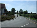
2
Brook Lane at the junction of High Street, Flitton
Image: © David Howard
Taken: 3 Apr 2019
0.09 miles
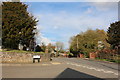
3
The White Hart pub, Brook Lane and St John the Baptist church, Flitton
Image: © Bikeboy
Taken: 2 Jan 2014
0.09 miles
5

Flitton cemetery
Cemetery set away from the church in Flitton
Image: © Barry Ephgrave
Taken: 4 Sep 2010
0.09 miles
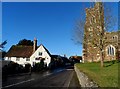
6
Flitton Village Hall
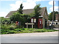
The Hall is on a sharp bend in the High Street opposite the Church. To the stranger whether this is the 'Flitton & Greenfield Village Hall' mentioned in various places on the internet is a moot point as all the mapping websites point to a location about 500 metres south of here. However the online Flitton Conservation Area brochure refers to this building as 'The Village Hall' so...
The road verge in front of the Hall is occupied by all sorts of village street furniture paraphernalia. Visible are the village postbox, the postman's letter storage cabinet, a water company marker headstone, the village sign, the parish notice board, a K6 telephone box, a road sign, a litter bin and a telegraph pole. The logo on the left side of village sign contains the date 1951 and commemorates 'The Festival of Britain' of that year.
Image: © Nigel Cox
Taken: 30 Jun 2008
0.09 miles

9
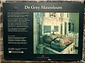
De Grey Mausoleum sign
This sign gives information about the De Grey Mausoleum which is attached to Image] and is cared for by English Heritage. When I visited I was unable to obtain the key from the address suggested - it was not even very obvious which house No.3 was !
Image: © Rob Farrow
Taken: 5 Mar 2008
0.10 miles
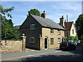
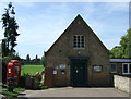
10
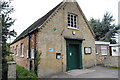
Flitton Church Hall
Church hall in Flitton, next to the White Hart
Image: © Barry Ephgrave
Taken: 4 Sep 2010
0.10 miles