IMAGES TAKEN NEAR TO
Moorland Close, BEDFORD, MK45 5DQ
Introduction
This page details the photographs taken nearby to Moorland Close, MK45 5DQ by members of the Geograph project.
The Geograph project started in 2005 with the aim of publishing, organising and preserving representative images for every square kilometre of Great Britain, Ireland and the Isle of Man.

There are currently over 7.5m images from over14,400 individuals and you can help contribute to the project by visiting https://www.geograph.org.uk
Image Map
Images are licensed for reuse under creativecommons.org/licenses/by-sa/2.0
Notes
- Clicking on the map will re-center to the selected point.
- The higher the marker number, the further away the image location is from the centre of the postcode.
Image Listing (5 Images Found)
Images are licensed for reuse under creativecommons.org/licenses/by-sa/2.0
Image
Details
Distance
2
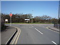
Junction of Pulloxhil Road with Flitton Road, Greenfield
Image: © JThomas
Taken: 25 Mar 2016
0.20 miles
3
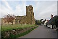
Flitton Church and surrounds
Flitton church has an attached mausoleum (visible on the left) for the de Grey family of Wrest Park, Silsoe.
Image: © Peter Roberts
Taken: 22 Apr 2005
0.20 miles
4
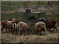
Livestock
A small flock of what I think are Manx Sheep.
Image: © Dennis simpson
Taken: 22 Feb 2009
0.23 miles
5
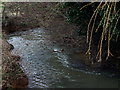
River Flit
Seen from Two moors Heritage trail.
Image: © Dennis simpson
Taken: 22 Feb 2009
0.24 miles