IMAGES TAKEN NEAR TO
Moat Farm Close, BEDFORD, MK45 5DP
Introduction
This page details the photographs taken nearby to Moat Farm Close, MK45 5DP by members of the Geograph project.
The Geograph project started in 2005 with the aim of publishing, organising and preserving representative images for every square kilometre of Great Britain, Ireland and the Isle of Man.

There are currently over 7.5m images from over14,400 individuals and you can help contribute to the project by visiting https://www.geograph.org.uk
Image Map
Images are licensed for reuse under creativecommons.org/licenses/by-sa/2.0
Notes
- Clicking on the map will re-center to the selected point.
- The higher the marker number, the further away the image location is from the centre of the postcode.
Image Listing (21 Images Found)
Images are licensed for reuse under creativecommons.org/licenses/by-sa/2.0
Image
Details
Distance
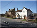
2
The Compasses public house, Greenfield
On High Street.
Image: © JThomas
Taken: 25 Mar 2016
0.13 miles
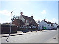
3
The Compasses, Greenfield
I assume this was a 'pub' but it is now a 'craft bar & restaurant.
Image: © Richard Rogerson
Taken: 1 Apr 2022
0.13 miles
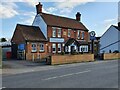
4
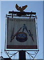
Sign for the Compasses public house, Greenfield
Image: © JThomas
Taken: 25 Mar 2016
0.14 miles
5
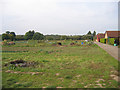
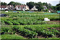
Joes Close, Greenfield, Beds
The allotments off the High Street.
Image: © Rodney Burton
Taken: 11 Oct 2005
0.15 miles
8
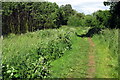
High Street
Heading south west from Greenfield.
Image: © JThomas
Taken: 25 Mar 2016
0.18 miles
9
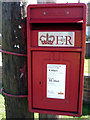
Close up, Elizabeth II postbox on High Street
Postbox No. MK45 377.
See Image] for context.
Image: © JThomas
Taken: 25 Mar 2016
0.19 miles
10
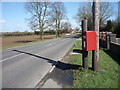
Elizabeth II postbox on High Street
Postbox No. MK45 377.
See Image] for close up.
Image: © JThomas
Taken: 25 Mar 2016
0.19 miles