IMAGES TAKEN NEAR TO
Cobblers Lane, BEDFORD, MK45 5AR
Introduction
This page details the photographs taken nearby to Cobblers Lane, MK45 5AR by members of the Geograph project.
The Geograph project started in 2005 with the aim of publishing, organising and preserving representative images for every square kilometre of Great Britain, Ireland and the Isle of Man.

There are currently over 7.5m images from over14,400 individuals and you can help contribute to the project by visiting https://www.geograph.org.uk
Image Map
Images are licensed for reuse under creativecommons.org/licenses/by-sa/2.0
Notes
- Clicking on the map will re-center to the selected point.
- The higher the marker number, the further away the image location is from the centre of the postcode.
Image Listing (6 Images Found)
Images are licensed for reuse under creativecommons.org/licenses/by-sa/2.0
Image
Details
Distance
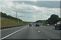
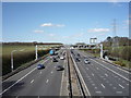
1

Central Bedfordshire : M1 Motorway
The M1 Motorway between Junction 13 (Ridgmont) and Junction 12 (Toddington).
Image: © Lewis Clarke
Taken: 3 Oct 2018
0.09 miles
3
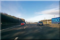
M1 northbound
Between junctions 12 and 13.
Image: © Robin Webster
Taken: 9 Dec 2017
0.12 miles
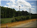
5
M1 northbound near Kingshoe Wood
From the over bridge.
Image: © JThomas
Taken: 25 Mar 2016
0.24 miles