IMAGES TAKEN NEAR TO
Flitwick Road, BEDFORD, MK45 5AA
Introduction
This page details the photographs taken nearby to Flitwick Road, MK45 5AA by members of the Geograph project.
The Geograph project started in 2005 with the aim of publishing, organising and preserving representative images for every square kilometre of Great Britain, Ireland and the Isle of Man.

There are currently over 7.5m images from over14,400 individuals and you can help contribute to the project by visiting https://www.geograph.org.uk
Image Map
Images are licensed for reuse under creativecommons.org/licenses/by-sa/2.0
Notes
- Clicking on the map will re-center to the selected point.
- The higher the marker number, the further away the image location is from the centre of the postcode.
Image Listing (11 Images Found)
Images are licensed for reuse under creativecommons.org/licenses/by-sa/2.0
Image
Details
Distance
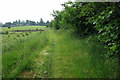
1
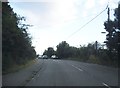
Flitwick Road between Flitwick and Westoning
Image: © David Howard
Taken: 28 Jul 2016
0.01 miles
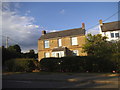
4

Flitt Vale Nurseries and Farm Shop
With a mustard yellow Austin Maxi leaving the car park.
Image: © Mark Anderson
Taken: 29 Mar 2015
0.09 miles
5
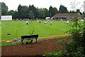
Games on the Flitwick Cricket Ground
Image: © Philip Jeffrey
Taken: 18 Jun 2013
0.14 miles
8
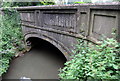
Bridge taking the A5120 over the Flit
Image: © Philip Jeffrey
Taken: 18 Jun 2013
0.19 miles
9
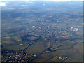
Flitwick from the air
Viewed from a Luton bound flight from Prague.
Image: © Thomas Nugent
Taken: 27 Feb 2013
0.19 miles
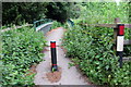
10
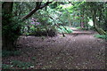
Path through the Priestlymoor Plantation
Image: © Philip Jeffrey
Taken: 18 Jun 2013
0.21 miles