IMAGES TAKEN NEAR TO
Lovett Green, BEDFORD, MK45 4SP
Introduction
This page details the photographs taken nearby to Lovett Green, MK45 4SP by members of the Geograph project.
The Geograph project started in 2005 with the aim of publishing, organising and preserving representative images for every square kilometre of Great Britain, Ireland and the Isle of Man.

There are currently over 7.5m images from over14,400 individuals and you can help contribute to the project by visiting https://www.geograph.org.uk
Image Map
Images are licensed for reuse under creativecommons.org/licenses/by-sa/2.0
Notes
- Clicking on the map will re-center to the selected point.
- The higher the marker number, the further away the image location is from the centre of the postcode.
Image Listing (19 Images Found)
Images are licensed for reuse under creativecommons.org/licenses/by-sa/2.0
Image
Details
Distance
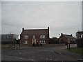
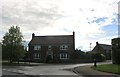
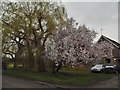
2
Houses, Lovett Green
A fairly up-market development of an industrial site.
Image: © Robin Webster
Taken: 13 Mar 2016
0.03 miles
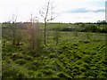
8
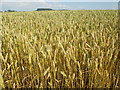
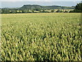
Bedfordshire wheat field
Sharpenhoe Clapper is seen peeping over the horizon.
Image: © Peter S
Taken: 24 Jul 2016
0.17 miles