IMAGES TAKEN NEAR TO
Plantation View, BEDFORD, MK45 4GG
Introduction
This page details the photographs taken nearby to Plantation View, MK45 4GG by members of the Geograph project.
The Geograph project started in 2005 with the aim of publishing, organising and preserving representative images for every square kilometre of Great Britain, Ireland and the Isle of Man.

There are currently over 7.5m images from over14,400 individuals and you can help contribute to the project by visiting https://www.geograph.org.uk
Image Map
Images are licensed for reuse under creativecommons.org/licenses/by-sa/2.0
Notes
- Clicking on the map will re-center to the selected point.
- The higher the marker number, the further away the image location is from the centre of the postcode.
Image Listing (20 Images Found)
Images are licensed for reuse under creativecommons.org/licenses/by-sa/2.0
Image
Details
Distance
1
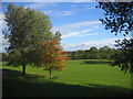
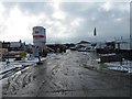
View from my office window, Silsoe, Beds
The lawn between the old NSRI building, Cranfield University, and Barton Road; taken on my last day clearing out the office after retirement.
Image: © Rodney Burton
Taken: 26 Oct 2006
0.03 miles
2
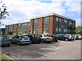
National Soil Resources Institute, Silsoe, Beds
part of Cranfield University at the Silsoe Campus on Barton Road.
Image: © Rodney Burton
Taken: 21 Jun 2006
0.08 miles