IMAGES TAKEN NEAR TO
Mander Farm Road, BEDFORD, MK45 4FW
Introduction
This page details the photographs taken nearby to Mander Farm Road, MK45 4FW by members of the Geograph project.
The Geograph project started in 2005 with the aim of publishing, organising and preserving representative images for every square kilometre of Great Britain, Ireland and the Isle of Man.

There are currently over 7.5m images from over14,400 individuals and you can help contribute to the project by visiting https://www.geograph.org.uk
Image Map (Loading...)


Getting Data...Please wait
Leaflet Map data © OpenStreetMap
Images are licensed for reuse under creativecommons.org/licenses/by-sa/2.0
Notes
- Clicking on the map will re-center to the selected point.
- The higher the marker number, the further away the image location is from the centre of the postcode.
Image Listing (19 Images Found)
Images are licensed for reuse under creativecommons.org/licenses/by-sa/2.0
Image
Details
Distance
3
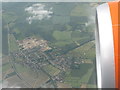
Silsoe - village from the air
Looking south, with new housing development to the south of the village, and the A6 Bedford-Luton Road, and the western part of the avenue leading to Wrest Park, on the left.
Image: © M J Richardson
Taken: 28 Jun 2012
0.10 miles
5
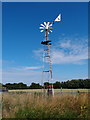
Wind driven water pump
Looks to be in working order but whether it pumps, I couldn't say. Located near the Silsoe Horticultural Centre.
Image: © Michael Trolove
Taken: 22 Jul 2012
0.13 miles

8
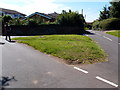
Grass triangle road junction in Silsoe
Located at the Junction of Vicarage Road and Church Road.
Image: © Michael Trolove
Taken: 22 Jul 2012
0.19 miles