IMAGES TAKEN NEAR TO
Yew Tree Close, BEDFORD, MK45 4EQ
Introduction
This page details the photographs taken nearby to Yew Tree Close, MK45 4EQ by members of the Geograph project.
The Geograph project started in 2005 with the aim of publishing, organising and preserving representative images for every square kilometre of Great Britain, Ireland and the Isle of Man.

There are currently over 7.5m images from over14,400 individuals and you can help contribute to the project by visiting https://www.geograph.org.uk
Image Map
Images are licensed for reuse under creativecommons.org/licenses/by-sa/2.0
Notes
- Clicking on the map will re-center to the selected point.
- The higher the marker number, the further away the image location is from the centre of the postcode.
Image Listing (50 Images Found)
Images are licensed for reuse under creativecommons.org/licenses/by-sa/2.0
Image
Details
Distance
1
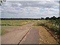
Bridleway
Looking down the bridleway (parallel to the A-road, from near the bridge over that road) -- the bridleway seems to have been redirected up here, so that cyclists and horses must use the bridge, now that the original bridleway course goes across a 60mph road
Image: © Oliver White
Taken: 22 Jun 2006
0.06 miles
3
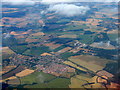
Silsoe and Wrest Park
Looking northeast over Bedfordshire, with the A6 passing from lower right to mid-left.
Image: © M J Richardson
Taken: 11 Jul 2018
0.07 miles
4
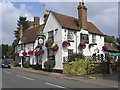
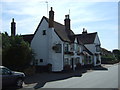
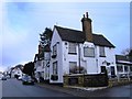
Star and Garter public house, Silsoe, Beds
The Star and Garter public house in the High Street, Silsoe; to the rear is part of the tower of St James' church.
Image: © Rodney Burton
Taken: 5 Sep 2005
0.08 miles
5
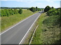
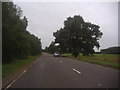
Silsoe: A6 Bypass (1)
The A6 bypass around Silsoe was opened in 1981 at a cost of £1.6 million. This view was taken from the bridge for the access road to Wrest Park. See Image for a view in the opposite direction.
Image: © Nigel Cox
Taken: 30 Jun 2008
0.09 miles
6
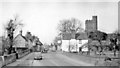
Entering Silsoe on the A6 in 1956
View northward on what is now Barton Road - High Street, an A6 by-pass having subsequently been built to the east of the village. Note - of course - the sparseness of traffic.
Image: © Ben Brooksbank
Taken: 23 Mar 1956
0.09 miles
8
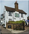
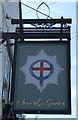
Silsoe - The Star and Garter
The Star and Garter public house in Silsoe, Beds is (I think) the nearest pub to Wrest Park, and so a natural watering hole for anyone visiting the fine EH property. The pub dates from the C18th with major alterations in the C19th.
It is EH Grade II listed, see http://list.english-heritage.org.uk/resultsingle.aspx?uid=1113779&searchtype=mapsearch
The pub's own website here http://www.starandgartersilsoe.co.uk
Image: © Rob Farrow
Taken: 5 May 2014
0.09 miles