IMAGES TAKEN NEAR TO
Willow Close, BEDFORD, MK45 4EN
Introduction
This page details the photographs taken nearby to Willow Close, MK45 4EN by members of the Geograph project.
The Geograph project started in 2005 with the aim of publishing, organising and preserving representative images for every square kilometre of Great Britain, Ireland and the Isle of Man.

There are currently over 7.5m images from over14,400 individuals and you can help contribute to the project by visiting https://www.geograph.org.uk
Image Map
Images are licensed for reuse under creativecommons.org/licenses/by-sa/2.0
Notes
- Clicking on the map will re-center to the selected point.
- The higher the marker number, the further away the image location is from the centre of the postcode.
Image Listing (17 Images Found)
Images are licensed for reuse under creativecommons.org/licenses/by-sa/2.0
Image
Details
Distance
1
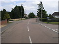
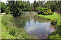
Newbury Lane
Newbury Lane passing The Grove
Image: © Shaun Ferguson
Taken: 14 Jul 2009
0.10 miles
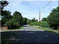
4
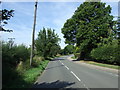
Ampthill Road
Heading north west from Silsoe.
Image: © JThomas
Taken: 22 Aug 2015
0.15 miles
5
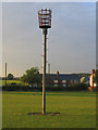
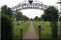
Millennium Beacon, Silsoe, Beds
Erected in 2000 on the Millennium Green at the northern end of the village of Silsoe.
Image: © Rodney Burton
Taken: 6 Sep 2005
0.16 miles
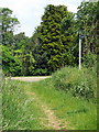
8
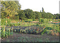
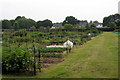
Allotments, Silsoe, Beds.
The village allotments are in the very south-west corner of the square, adjacent to the Millennium Green.
Image: © Rodney Burton
Taken: 6 Sep 2005
0.20 miles