IMAGES TAKEN NEAR TO
Old Kiln Lane, BEDFORD, MK45 4BU
Introduction
This page details the photographs taken nearby to Old Kiln Lane, MK45 4BU by members of the Geograph project.
The Geograph project started in 2005 with the aim of publishing, organising and preserving representative images for every square kilometre of Great Britain, Ireland and the Isle of Man.

There are currently over 7.5m images from over14,400 individuals and you can help contribute to the project by visiting https://www.geograph.org.uk
Image Map
Images are licensed for reuse under creativecommons.org/licenses/by-sa/2.0
Notes
- Clicking on the map will re-center to the selected point.
- The higher the marker number, the further away the image location is from the centre of the postcode.
Image Listing (5 Images Found)
Images are licensed for reuse under creativecommons.org/licenses/by-sa/2.0
Image
Details
Distance
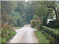
1
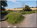
Road junction with grass covering
At the junction of Old Kiln Lane with Kiln Lane.
Image: © Michael Trolove
Taken: 22 Jul 2012
0.09 miles
2
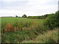
Farmland west of Great Lane, Clophill, Beds
– looking across the Chalky Boulder Clay plateau.
Image: © Rodney Burton
Taken: 13 Oct 2005
0.19 miles
4
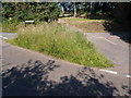
Triangular road junction in Clophill
More a grassy knoll at the junction of Little Lane and Kiln Lane.
Image: © Michael Trolove
Taken: 22 Jul 2012
0.23 miles
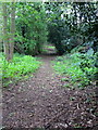
5
Greensand Ridge Walk
On the GRW heading north out of Clophill
Image: © Dennis simpson
Taken: 2 Nov 2008
0.25 miles