IMAGES TAKEN NEAR TO
The Causeway, BEDFORD, MK45 4BA
Introduction
This page details the photographs taken nearby to The Causeway, MK45 4BA by members of the Geograph project.
The Geograph project started in 2005 with the aim of publishing, organising and preserving representative images for every square kilometre of Great Britain, Ireland and the Isle of Man.

There are currently over 7.5m images from over14,400 individuals and you can help contribute to the project by visiting https://www.geograph.org.uk
Image Map
Images are licensed for reuse under creativecommons.org/licenses/by-sa/2.0
Notes
- Clicking on the map will re-center to the selected point.
- The higher the marker number, the further away the image location is from the centre of the postcode.
Image Listing (9 Images Found)
Images are licensed for reuse under creativecommons.org/licenses/by-sa/2.0
Image
Details
Distance
5
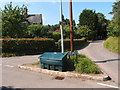
Mill Lane, Kiln Lane road junction
A small grass and kerbed traffic island in Clophill
Image: © Michael Trolove
Taken: 22 Jul 2012
0.19 miles
6
Mace shop, Clophill
I think it used to be a Post Office (P.O. marked close by on the O.S. map)
Image: © Bikeboy
Taken: 2 Jan 2014
0.21 miles
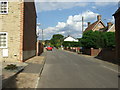
8
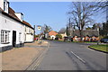
Looking along the High Street in Clophill, Beds
The Green Man is on the left opposite the Green, on some maps the public house is named as the Flying Horse.
Image: © Mick Malpass
Taken: 15 Mar 2012
0.25 miles
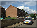
9
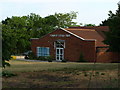
Clophill Village Hall
Village hall with the makings of a small allotment just at the bottom right of the image.
Image: © Dennis simpson
Taken: 19 May 2011
0.25 miles