IMAGES TAKEN NEAR TO
West End, BEDFORD, MK45 3UZ
Introduction
This page details the photographs taken nearby to West End, MK45 3UZ by members of the Geograph project.
The Geograph project started in 2005 with the aim of publishing, organising and preserving representative images for every square kilometre of Great Britain, Ireland and the Isle of Man.

There are currently over 7.5m images from over14,400 individuals and you can help contribute to the project by visiting https://www.geograph.org.uk
Image Map
Images are licensed for reuse under creativecommons.org/licenses/by-sa/2.0
Notes
- Clicking on the map will re-center to the selected point.
- The higher the marker number, the further away the image location is from the centre of the postcode.
Image Listing (17 Images Found)
Images are licensed for reuse under creativecommons.org/licenses/by-sa/2.0
Image
Details
Distance
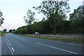
1
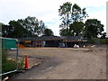
Building work adjacent to Maulden Wood
Looks to be a visitor centre in construction. http://www.greensandtrust.org/WorkingWoodland/index2.html
Image: © Michael Trolove
Taken: 22 Jul 2012
0.01 miles
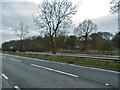
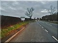
3
Looking Northwards on the A6 near Clophill
Image: © Mick Malpass
Taken: 15 Mar 2012
0.02 miles
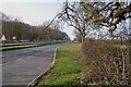
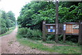
7
Maulden Wood, Beds
Trail guide near the A6 lay-by north of Clophill.
Image: © Rodney Burton
Taken: 12 Oct 2005
0.05 miles
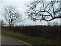
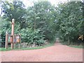
10
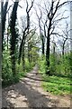
Path in Maulden Wood
A path going south from the A6 entrance to Maulden Wood.
Image: © Bob Walters
Taken: 15 Apr 2022
0.08 miles