IMAGES TAKEN NEAR TO
Silver End Road, BEDFORD, MK45 3PU
Introduction
This page details the photographs taken nearby to Silver End Road, MK45 3PU by members of the Geograph project.
The Geograph project started in 2005 with the aim of publishing, organising and preserving representative images for every square kilometre of Great Britain, Ireland and the Isle of Man.

There are currently over 7.5m images from over14,400 individuals and you can help contribute to the project by visiting https://www.geograph.org.uk
Image Map
Images are licensed for reuse under creativecommons.org/licenses/by-sa/2.0
Notes
- Clicking on the map will re-center to the selected point.
- The higher the marker number, the further away the image location is from the centre of the postcode.
Image Listing (6 Images Found)
Images are licensed for reuse under creativecommons.org/licenses/by-sa/2.0
Image
Details
Distance
1
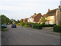
Silver End Road, Haynes, Beds
– view along the main street in Haynes from near the Methodist Chapel towards the A600.
Image: © Rodney Burton
Taken: 25 May 2006
0.04 miles
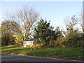
3
Haynes end at the junction of the A600
Image: © David Howard
Taken: 29 Jul 2019
0.08 miles
4
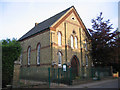
Methodist Chapel, Silver End, Haynes, Beds
The foundation stones were laid in Aug 1874.
Image: © Rodney Burton
Taken: 25 May 2006
0.16 miles
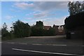
5
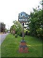
Village sign, Haynes Silver End, Beds
in Silver End Road depicting St Mary's church; the bus shelter and parish seats are behind.
Image: © Rodney Burton
Taken: 25 May 2006
0.21 miles
6
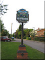
Village sign, Haynes Silver End, Beds
depicting Haynes Park Mansion and agriculture.
Image: © Rodney Burton
Taken: 25 May 2006
0.21 miles