IMAGES TAKEN NEAR TO
Waterway Place, BEDFORD, MK45 3NU
Introduction
This page details the photographs taken nearby to Waterway Place, MK45 3NU by members of the Geograph project.
The Geograph project started in 2005 with the aim of publishing, organising and preserving representative images for every square kilometre of Great Britain, Ireland and the Isle of Man.

There are currently over 7.5m images from over14,400 individuals and you can help contribute to the project by visiting https://www.geograph.org.uk
Image Map
Images are licensed for reuse under creativecommons.org/licenses/by-sa/2.0
Notes
- Clicking on the map will re-center to the selected point.
- The higher the marker number, the further away the image location is from the centre of the postcode.
Image Listing (11 Images Found)
Images are licensed for reuse under creativecommons.org/licenses/by-sa/2.0
Image
Details
Distance
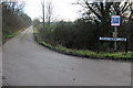
2
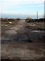
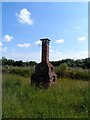
Access road through demolished industrial estate
You can almost see the airship hangars on the horizon
Image: © Philip Jeffrey
Taken: 21 Jan 2014
0.08 miles
4
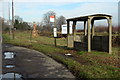
Bus stop and protest post by the Bedford Road
The brick post was erected by Bedford Against Nuclear Dump in 1986
Image: © Philip Jeffrey
Taken: 21 Jan 2014
0.09 miles
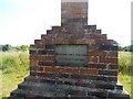
5
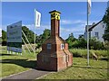
Brick monument
The monument was erected in 1986 as a protest against a plan to dump nuclear waste on the site of the former Royal Ordnance Factory nearby. The plan to dump the waste never went ahead. See http://www.geograph.org.uk/photo/4547774 and http://www.geograph.org.uk/photo/4547789 for close-ups of the monument.
Image: © Bikeboy
Taken: 27 Jun 2015
0.11 miles
6
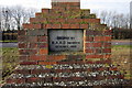
Inscription on brick monument (1)
See http://www.geograph.org.uk/photo/4547763 for a picture of the whole monument.
Image: © Bikeboy
Taken: 27 Jun 2015
0.11 miles
7
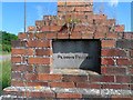
Inscription on brick monument (2)
See http://www.geograph.org.uk/photo/4547763 for a picture of the whole monument.
Image: © Bikeboy
Taken: 27 Jun 2015
0.11 miles
8
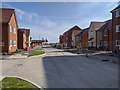
New houses being built in Horseshoe Crescent, Tavistock Green, off Ampthill Road
Image: © Rob Purvis
Taken: 13 Sep 2020
0.13 miles
10
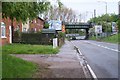
Railway Bridge at Kemspton Hardwick
Long standing terrace of cottages just to the left of the image
Image: © Dennis simpson
Taken: 11 May 2006
0.20 miles