IMAGES TAKEN NEAR TO
Bird Court, BEDFORD, MK45 3FW
Introduction
This page details the photographs taken nearby to Bird Court, MK45 3FW by members of the Geograph project.
The Geograph project started in 2005 with the aim of publishing, organising and preserving representative images for every square kilometre of Great Britain, Ireland and the Isle of Man.

There are currently over 7.5m images from over14,400 individuals and you can help contribute to the project by visiting https://www.geograph.org.uk
Image Map
Images are licensed for reuse under creativecommons.org/licenses/by-sa/2.0
Notes
- Clicking on the map will re-center to the selected point.
- The higher the marker number, the further away the image location is from the centre of the postcode.
Image Listing (13 Images Found)
Images are licensed for reuse under creativecommons.org/licenses/by-sa/2.0
Image
Details
Distance
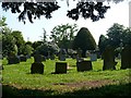
2

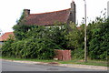
Old Cottages, Wilstead
The thatched cottage on the left is named 'Winters Moon'.
Image: © Robin Drayton
Taken: 20 May 2008
0.11 miles
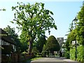
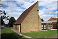
5
Old Church House, Wilstead
Near the entrance to Image
Image: © Robin Drayton
Taken: 12 May 2008
0.13 miles
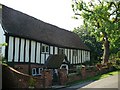
7
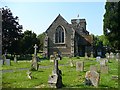
All Saints Church, Wilstead
A timeline for Wilstead can be seen here - http://www.galaxy.bedfordshire.gov.uk/webingres/bedfordshire/vlib/0.digitised_resources/wilstead_timeline.htm .
Image: © Robin Drayton
Taken: 12 May 2008
0.15 miles
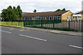
9
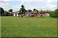
Play equipment on the recreation ground
Image: © Philip Jeffrey
Taken: 10 Aug 2013
0.19 miles
10
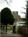
All Saints, Wilshamstead; Church & Gateway
A view of the church though the Eastern gateway. The signboard names the village as Wilshamstead (Cf Wilstead on current OS map). More on Wilshamstead & the church here http://www.british-history.ac.uk/report.asp?compid=42441
Image: © Rob Farrow
Taken: 13 Mar 2006
0.19 miles