IMAGES TAKEN NEAR TO
Oakley Rise, BEDFORD, MK45 3FD
Introduction
This page details the photographs taken nearby to Oakley Rise, MK45 3FD by members of the Geograph project.
The Geograph project started in 2005 with the aim of publishing, organising and preserving representative images for every square kilometre of Great Britain, Ireland and the Isle of Man.

There are currently over 7.5m images from over14,400 individuals and you can help contribute to the project by visiting https://www.geograph.org.uk
Image Map
Images are licensed for reuse under creativecommons.org/licenses/by-sa/2.0
Notes
- Clicking on the map will re-center to the selected point.
- The higher the marker number, the further away the image location is from the centre of the postcode.
Image Listing (16 Images Found)
Images are licensed for reuse under creativecommons.org/licenses/by-sa/2.0
Image
Details
Distance
1
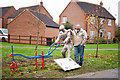
Wilstead Man
I have been commissioned by Wilstead Parish Council to generate a sculpture using the subject of our farming History. Interviews with some prominent people gave me a body of text on this topic. This text is replicated in the form of a man guiding a horse drawn Scuffle or Hoe.
The hollow section of the landworker (Hossman) is going to be back pored with concrete.
The text :
The names are the largest lettering 100mm
The interview text is 60mm and 40mm (40mm text for finer detail parts of the body).
see http://www.paulpibworth.co.uk/the-wilstead-man.html
Image: © Matt Givertz
Taken: 29 Nov 2014
0.07 miles
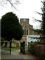
3
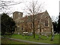
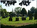
All Saints Church, Wilshamstead (Wilstead)
This church is built of very pleasantly coloured stone, which I think is fairly common in the locality. More on Wilshamstead & the church here http://www.british-history.ac.uk/report.asp?compid=42441
The village seems to have dropped its middle "hams" on current maps being called "Wilstead", but the church signboard and the 1940s map both call it "Wilshamstead".
Image: © Rob Farrow
Taken: 13 Mar 2006
0.14 miles
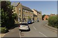
4
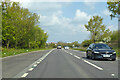
A6 towards Bedford
Bypassing Wilstead.
Image: © Robin Webster
Taken: 2 May 2021
0.14 miles
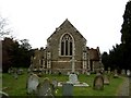
7
All Saints, Wilshamstead; Church & Gateway
A view of the church though the Eastern gateway. The signboard names the village as Wilshamstead (Cf Wilstead on current OS map). More on Wilshamstead & the church here http://www.british-history.ac.uk/report.asp?compid=42441
Image: © Rob Farrow
Taken: 13 Mar 2006
0.20 miles
8
All Saints, Wilshamstead (or Wilstead) East End
The church's tower is almost invisible from this angle.
More on Wilshamstead & the church here http://www.british-history.ac.uk/report.asp?compid=42441
Image: © Rob Farrow
Taken: 13 Mar 2006
0.20 miles
10
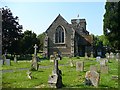
All Saints Church, Wilstead
A timeline for Wilstead can be seen here - http://www.galaxy.bedfordshire.gov.uk/webingres/bedfordshire/vlib/0.digitised_resources/wilstead_timeline.htm .
Image: © Robin Drayton
Taken: 12 May 2008
0.22 miles