IMAGES TAKEN NEAR TO
Morgans Close, BEDFORD, MK45 3EB
Introduction
This page details the photographs taken nearby to Morgans Close, MK45 3EB by members of the Geograph project.
The Geograph project started in 2005 with the aim of publishing, organising and preserving representative images for every square kilometre of Great Britain, Ireland and the Isle of Man.

There are currently over 7.5m images from over14,400 individuals and you can help contribute to the project by visiting https://www.geograph.org.uk
Image Map
Images are licensed for reuse under creativecommons.org/licenses/by-sa/2.0
Notes
- Clicking on the map will re-center to the selected point.
- The higher the marker number, the further away the image location is from the centre of the postcode.
Image Listing (9 Images Found)
Images are licensed for reuse under creativecommons.org/licenses/by-sa/2.0
Image
Details
Distance
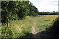
1
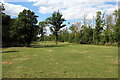
Wedge shaped parkland by Carriage Drive
Image: © Philip Jeffrey
Taken: 10 Aug 2013
0.14 miles
2
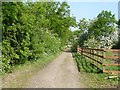
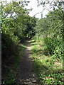
Carriage Drive, Wilstead
This permissive path was the rear drive from Wilstead to Image
Image: © Robin Drayton
Taken: 12 May 2008
0.15 miles
4
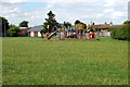
Play equipment on the recreation ground
Image: © Philip Jeffrey
Taken: 10 Aug 2013
0.19 miles
7
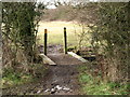
Footbridge
Small footbridge on the footpath just south of Wilstead
Image: © Dennis simpson
Taken: 31 Jan 2010
0.22 miles