IMAGES TAKEN NEAR TO
Haynes Park, Church End, BEDFORD, MK45 3BJ
Introduction
This page details the photographs taken nearby to Haynes Park, Church End, MK45 3BJ by members of the Geograph project.
The Geograph project started in 2005 with the aim of publishing, organising and preserving representative images for every square kilometre of Great Britain, Ireland and the Isle of Man.

There are currently over 7.5m images from over14,400 individuals and you can help contribute to the project by visiting https://www.geograph.org.uk
Image Map
Images are licensed for reuse under creativecommons.org/licenses/by-sa/2.0
Notes
- Clicking on the map will re-center to the selected point.
- The higher the marker number, the further away the image location is from the centre of the postcode.
Image Listing (5 Images Found)
Images are licensed for reuse under creativecommons.org/licenses/by-sa/2.0
Image
Details
Distance
1
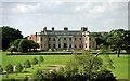
Hawnes, Haynes Church End
Also known as Haynes Park. A large square low house. It was started c1720 for Lord Grenville, and James Lewis may have added the white-brick south front, seen here, in 1790 for Lord Carteret. The bowed ends and pilastered centrepiece are distinctive features. Grade I listed.
It was a school for most of the C20th, but now appears to be a base of the Satsang Programme at the apparently oxymoronic "Science of the Soul Study Centre".
Image: © Stephen Richards
Taken: Unknown
0.14 miles
2
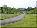
Haynes Park, Haynes Church End, Beds
Haynes Park Mansion is a Georgian residence built by Robert Newdygate (Newdigate); dating from about 1721, the south front was added in 1790. http://www.haynesvillageuk.co.uk/8.html
Image: © Rodney Burton
Taken: 25 May 2006
0.14 miles
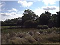
5
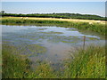
Pond at top of Firtree Hill
Wilstead Wood beyond the sheep field boundary
Image: © ian saunders
Taken: 5 Aug 2007
0.25 miles