IMAGES TAKEN NEAR TO
Hammer Hill, BEDFORD, MK45 3BH
Introduction
This page details the photographs taken nearby to Hammer Hill, MK45 3BH by members of the Geograph project.
The Geograph project started in 2005 with the aim of publishing, organising and preserving representative images for every square kilometre of Great Britain, Ireland and the Isle of Man.

There are currently over 7.5m images from over14,400 individuals and you can help contribute to the project by visiting https://www.geograph.org.uk
Image Map
Images are licensed for reuse under creativecommons.org/licenses/by-sa/2.0
Notes
- Clicking on the map will re-center to the selected point.
- The higher the marker number, the further away the image location is from the centre of the postcode.
Image Listing (4 Images Found)
Images are licensed for reuse under creativecommons.org/licenses/by-sa/2.0
Image
Details
Distance
1
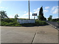
Entrance to Summerfield Miniature Railway (amongst other things)
Image: © Jeff Tomlinson
Taken: 7 May 2007
0.05 miles
2
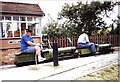
Summerfield Miniature Railway, Haynes, Bedfordshire
The little railway works most summer weekends and although not shown on the
1:50,000 map, works its way north-west for about a mile. (Click on the map below to see the 1:25,000 or larger scale maps on which the railway is shown.) Summerfield Miniature Railway is operated by the Bedford Model Engineers Society. Details of running days open to the public can be found at http://www.bedfordmes.co.uk
Image: © nick macneill
Taken: Unknown
0.08 miles
4
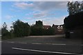
Haynes end at the junction of the A600
Image: © David Howard
Taken: 29 Jul 2019
0.23 miles