IMAGES TAKEN NEAR TO
Hermitage Gardens, BEDFORD, MK45 3AY
Introduction
This page details the photographs taken nearby to Hermitage Gardens, MK45 3AY by members of the Geograph project.
The Geograph project started in 2005 with the aim of publishing, organising and preserving representative images for every square kilometre of Great Britain, Ireland and the Isle of Man.

There are currently over 7.5m images from over14,400 individuals and you can help contribute to the project by visiting https://www.geograph.org.uk
Image Map
Images are licensed for reuse under creativecommons.org/licenses/by-sa/2.0
Notes
- Clicking on the map will re-center to the selected point.
- The higher the marker number, the further away the image location is from the centre of the postcode.
Image Listing (10 Images Found)
Images are licensed for reuse under creativecommons.org/licenses/by-sa/2.0
Image
Details
Distance
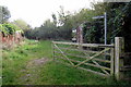
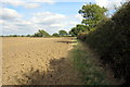
2
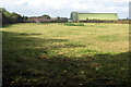
Cattle field in the shadow of the hangars
Image: © Philip Jeffrey
Taken: 3 Oct 2014
0.10 miles
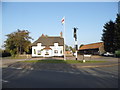
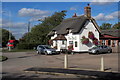
5
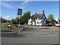
"The Bell"
The Bell is an old, probably 17th century, thatched pub.
Image: © Jeff Tomlinson
Taken: 7 May 2007
0.14 miles
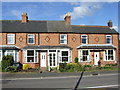
8
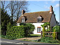
21 High Road, Cotton End
An pretty 18th Century cottage.
Image: © Jeff Tomlinson
Taken: 7 May 2007
0.22 miles
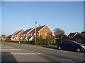
10
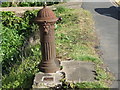
Water pump in front of houses on High Road, Cotton End
Image: © Jeff Tomlinson
Taken: 7 May 2007
0.23 miles