IMAGES TAKEN NEAR TO
John Bunyan Close, BEDFORD, MK45 2XA
Introduction
This page details the photographs taken nearby to John Bunyan Close, MK45 2XA by members of the Geograph project.
The Geograph project started in 2005 with the aim of publishing, organising and preserving representative images for every square kilometre of Great Britain, Ireland and the Isle of Man.

There are currently over 7.5m images from over14,400 individuals and you can help contribute to the project by visiting https://www.geograph.org.uk
Image Map
Images are licensed for reuse under creativecommons.org/licenses/by-sa/2.0
Notes
- Clicking on the map will re-center to the selected point.
- The higher the marker number, the further away the image location is from the centre of the postcode.
Image Listing (20 Images Found)
Images are licensed for reuse under creativecommons.org/licenses/by-sa/2.0
Image
Details
Distance
2
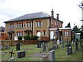
Baptist Church, Maulden, Beds
on the Flitwick Road.
Image: © Rodney Burton
Taken: 22 Jun 2006
0.02 miles
5
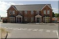
Former site of the Black Horse public house
A recreation of this photograph taken in 2006: Image
Image: © Mark Anderson
Taken: 24 Jul 2018
0.10 miles
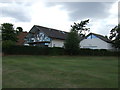
6
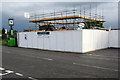
The demise of the Black Horse pub
Soon to be Victorian style villas, apparently
Image: © Philip Jeffrey
Taken: 11 May 2013
0.11 miles
7
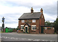
Black Horse public house, Maulden, Beds
on the Ampthill Road; view from Snow Hill.
Image: © Rodney Burton
Taken: 22 Jun 2006
0.12 miles
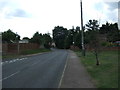
8
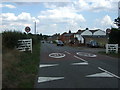
Entering Maulden
Heading east on Ampthill Road.
Image: © JThomas
Taken: 22 Aug 2015
0.12 miles
10
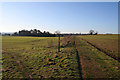
Footpath from Maulden to Ampthill
This footpath crosses two large fields on its way to Ampthill.
Image: © Mark Anderson
Taken: 1 Jan 2010
0.14 miles