IMAGES TAKEN NEAR TO
Tavistock Avenue, BEDFORD, MK45 2RY
Introduction
This page details the photographs taken nearby to Tavistock Avenue, MK45 2RY by members of the Geograph project.
The Geograph project started in 2005 with the aim of publishing, organising and preserving representative images for every square kilometre of Great Britain, Ireland and the Isle of Man.

There are currently over 7.5m images from over14,400 individuals and you can help contribute to the project by visiting https://www.geograph.org.uk
Image Map
Images are licensed for reuse under creativecommons.org/licenses/by-sa/2.0
Notes
- Clicking on the map will re-center to the selected point.
- The higher the marker number, the further away the image location is from the centre of the postcode.
Image Listing (27 Images Found)
Images are licensed for reuse under creativecommons.org/licenses/by-sa/2.0
Image
Details
Distance

5
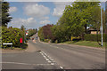
Flitwick Road, Ampthill
A closer view of the postbox can be seen here: Image
Image: © Mark Anderson
Taken: 5 May 2013
0.11 miles
6
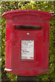
Elizabeth II Postbox, Flitwick Road
Near the junction with Grange Road.
Image: © Mark Anderson
Taken: 5 May 2013
0.11 miles
7
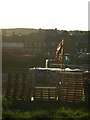
Ampthill Heights
Building site. New estate called Ampthill Heights. Strange name given that it is in the lowest point in Ampthill.
Image: © Dennis simpson
Taken: 20 May 2011
0.11 miles