IMAGES TAKEN NEAR TO
Flitwick Road, BEDFORD, MK45 2RL
Introduction
This page details the photographs taken nearby to Flitwick Road, MK45 2RL by members of the Geograph project.
The Geograph project started in 2005 with the aim of publishing, organising and preserving representative images for every square kilometre of Great Britain, Ireland and the Isle of Man.

There are currently over 7.5m images from over14,400 individuals and you can help contribute to the project by visiting https://www.geograph.org.uk
Image Map
Images are licensed for reuse under creativecommons.org/licenses/by-sa/2.0
Notes
- Clicking on the map will re-center to the selected point.
- The higher the marker number, the further away the image location is from the centre of the postcode.
Image Listing (22 Images Found)
Images are licensed for reuse under creativecommons.org/licenses/by-sa/2.0
Image
Details
Distance
1
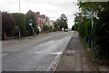
Pedestrian crossing on Flitwick Road
Image: © Philip Jeffrey
Taken: 11 May 2013
0.02 miles
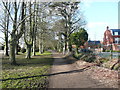
2

Private road at the end of Ashburnham Road
Image: © Philip Jeffrey
Taken: 11 May 2013
0.06 miles
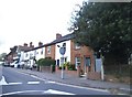
4
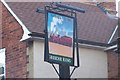
The Engine and Tender
On the main drag through Ampthill
Image: © Dennis simpson
Taken: 16 Aug 2007
0.09 miles
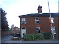
6

Former Town Hall, Ampthill
Now offices.
Image: © Mark Anderson
Taken: 22 Dec 2019
0.11 miles
7
Bridleway off Station Road, Ampthill
Image: © Humphrey Bolton
Taken: 19 Mar 2018
0.13 miles
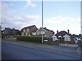
8
The Firs Lower School
One of two lower schools in Ampthill.
Image: © Dennis simpson
Taken: 6 Apr 2008
0.14 miles
10
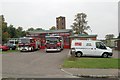
Ampthill fire station
Ampthill fire station, Oliver Street, Ampthill, Bedfordshire, with a Volvo and a Scania appliance on the forecourt
Image: © Kevin Hale
Taken: 7 Oct 2007
0.19 miles