IMAGES TAKEN NEAR TO
Ampthill Business Park, BEDFORD, MK45 2QW
Introduction
This page details the photographs taken nearby to Ampthill Business Park, MK45 2QW by members of the Geograph project.
The Geograph project started in 2005 with the aim of publishing, organising and preserving representative images for every square kilometre of Great Britain, Ireland and the Isle of Man.

There are currently over 7.5m images from over14,400 individuals and you can help contribute to the project by visiting https://www.geograph.org.uk
Image Map
Images are licensed for reuse under creativecommons.org/licenses/by-sa/2.0
Notes
- Clicking on the map will re-center to the selected point.
- The higher the marker number, the further away the image location is from the centre of the postcode.
Image Listing (12 Images Found)
Images are licensed for reuse under creativecommons.org/licenses/by-sa/2.0
Image
Details
Distance
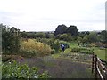
3
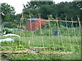
Allotment Gardens
On the site of an old farm.
Image: © Dennis simpson
Taken: 5 Jun 2008
0.09 miles
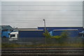
4
New Housing development on A507 Ampthill
New housing development on an old factory site at the end of Station Road, Ampthill. 250 houses are to be built behind making this whole area residential.
Image: © Marcus de Figueiredo
Taken: 24 Mar 2007
0.10 miles
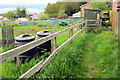
5
Grange Farm Allotments
A prize-winning allotment
Image: © James Wood
Taken: 8 Aug 2001
0.13 miles
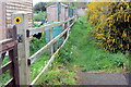
7
Path to the allotments by Farm Close
Image: © Philip Jeffrey
Taken: 11 May 2013
0.15 miles
9
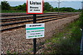
Message - Despair
Seems like a good place to put this message.
Image: © Barry Ephgrave
Taken: 5 Jun 2010
0.20 miles
10
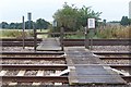
Footpath
Footpath crossing the Midland Mainline railway line
Image: © Dennis simpson
Taken: 30 Aug 2007
0.22 miles