IMAGES TAKEN NEAR TO
Flitwick Road, BEDFORD, MK45 2NT
Introduction
This page details the photographs taken nearby to Flitwick Road, MK45 2NT by members of the Geograph project.
The Geograph project started in 2005 with the aim of publishing, organising and preserving representative images for every square kilometre of Great Britain, Ireland and the Isle of Man.

There are currently over 7.5m images from over14,400 individuals and you can help contribute to the project by visiting https://www.geograph.org.uk
Image Map
Images are licensed for reuse under creativecommons.org/licenses/by-sa/2.0
Notes
- Clicking on the map will re-center to the selected point.
- The higher the marker number, the further away the image location is from the centre of the postcode.
Image Listing (31 Images Found)
Images are licensed for reuse under creativecommons.org/licenses/by-sa/2.0
Image
Details
Distance

9
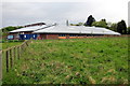
Sheepish
Sheep kept by the local upper school.
Image: © Dennis simpson
Taken: 20 May 2011
0.16 miles
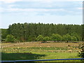
10
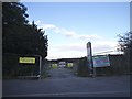
A soon to be ex-field
The green belt is creeping back as this field is now reserved for housing
Image: © David Howard
Taken: 28 Jul 2016
0.16 miles