IMAGES TAKEN NEAR TO
Flitwick Road, BEDFORD, MK45 2NS
Introduction
This page details the photographs taken nearby to Flitwick Road, MK45 2NS by members of the Geograph project.
The Geograph project started in 2005 with the aim of publishing, organising and preserving representative images for every square kilometre of Great Britain, Ireland and the Isle of Man.

There are currently over 7.5m images from over14,400 individuals and you can help contribute to the project by visiting https://www.geograph.org.uk
Image Map (Loading...)


Getting Data...Please wait
Leaflet Map data © OpenStreetMap
Images are licensed for reuse under creativecommons.org/licenses/by-sa/2.0
Notes
- Clicking on the map will re-center to the selected point.
- The higher the marker number, the further away the image location is from the centre of the postcode.
Image Listing (22 Images Found)
Images are licensed for reuse under creativecommons.org/licenses/by-sa/2.0
Image
Details
Distance
3
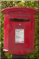
Elizabeth II Postbox, Flitwick Road
Near the junction with Grange Road.
Image: © Mark Anderson
Taken: 5 May 2013
0.12 miles
4
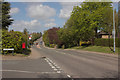
Flitwick Road, Ampthill
A closer view of the postbox can be seen here: Image
Image: © Mark Anderson
Taken: 5 May 2013
0.12 miles
5
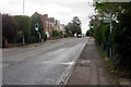
Pedestrian crossing on Flitwick Road
Image: © Philip Jeffrey
Taken: 11 May 2013
0.14 miles
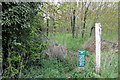
6

Private road at the end of Ashburnham Road
Image: © Philip Jeffrey
Taken: 11 May 2013
0.17 miles
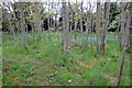
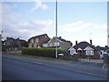
9
A soon to be ex-field
The green belt is creeping back as this field is now reserved for housing
Image: © David Howard
Taken: 28 Jul 2016
0.19 miles
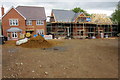
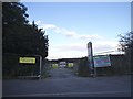
10
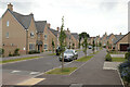
Poppy Drive, Ampthill
A new housing development to the South of Ampthill.
Image: © Mark Anderson
Taken: 2 Jun 2022
0.20 miles