IMAGES TAKEN NEAR TO
Dunstable Street, BEDFORD, MK45 2JR
Introduction
This page details the photographs taken nearby to Dunstable Street, MK45 2JR by members of the Geograph project.
The Geograph project started in 2005 with the aim of publishing, organising and preserving representative images for every square kilometre of Great Britain, Ireland and the Isle of Man.

There are currently over 7.5m images from over14,400 individuals and you can help contribute to the project by visiting https://www.geograph.org.uk
Image Map
Images are licensed for reuse under creativecommons.org/licenses/by-sa/2.0
Notes
- Clicking on the map will re-center to the selected point.
- The higher the marker number, the further away the image location is from the centre of the postcode.
Image Listing (120 Images Found)
Images are licensed for reuse under creativecommons.org/licenses/by-sa/2.0
Image
Details
Distance
3
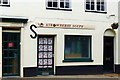
Strawberry Soupe, Dunstable Street, Amptill
A Wholesome Food Emporium, it claims on the shop sign.
Image: © Cameraman
Taken: 12 May 2011
0.02 miles
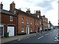
5
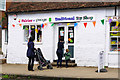
Fairies 'n' Frogs , Dunstable Street, Ampthill
A Traditional Toy Shop.
Image: © Cameraman
Taken: 12 May 2011
0.03 miles

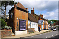
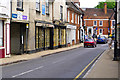
7
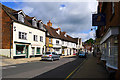
Dunstable Street, Ampthill
Looking towards the town centre.
Image: © Cameraman
Taken: 12 May 2011
0.04 miles
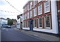
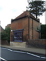
10
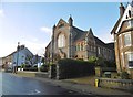
Ampthill Methodist Church
On Dunstable Road. Foundation stones are dated 1883. http://www.ampthillmethodist.org.uk/amchistory.htm
Image: © Mike Faherty
Taken: 28 Nov 2017
0.06 miles