IMAGES TAKEN NEAR TO
Claridges Lane, BEDFORD, MK45 2HU
Introduction
This page details the photographs taken nearby to Claridges Lane, MK45 2HU by members of the Geograph project.
The Geograph project started in 2005 with the aim of publishing, organising and preserving representative images for every square kilometre of Great Britain, Ireland and the Isle of Man.

There are currently over 7.5m images from over14,400 individuals and you can help contribute to the project by visiting https://www.geograph.org.uk
Image Map
Images are licensed for reuse under creativecommons.org/licenses/by-sa/2.0
Notes
- Clicking on the map will re-center to the selected point.
- The higher the marker number, the further away the image location is from the centre of the postcode.
Image Listing (106 Images Found)
Images are licensed for reuse under creativecommons.org/licenses/by-sa/2.0
Image
Details
Distance
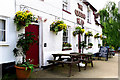
1
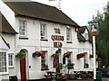
Queens Head, Ampthill
Top notch Charles Wells pub.
Image: © Dennis simpson
Taken: 16 Aug 2008
0.02 miles
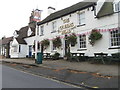
4
The Queens Head, Ampthill
On Woburn Street.
Image: © JThomas
Taken: 22 Aug 2015
0.03 miles
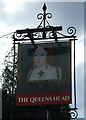
5
The Queen's Head, Woburn Street, Ampthill
Image: © Cameraman
Taken: 12 May 2011
0.03 miles
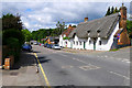
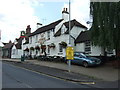
8
Ampthill, Woburn Street
Looking from the brow of the hill towards the town centre.
Image: © Mike Faherty
Taken: 28 Nov 2017
0.04 miles
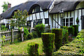
9
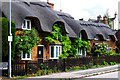
Row of 'Ossery' Estate Cottages, Woburn Street, Ampthill
Image: © Cameraman
Taken: 12 May 2011
0.04 miles
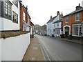
10
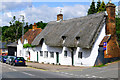
Thatched Cottages, Woburn Street, Ampthill
Image: © Cameraman
Taken: 12 May 2011
0.05 miles