IMAGES TAKEN NEAR TO
Limbersey Lane, BEDFORD, MK45 2EB
Introduction
This page details the photographs taken nearby to Limbersey Lane, MK45 2EB by members of the Geograph project.
The Geograph project started in 2005 with the aim of publishing, organising and preserving representative images for every square kilometre of Great Britain, Ireland and the Isle of Man.

There are currently over 7.5m images from over14,400 individuals and you can help contribute to the project by visiting https://www.geograph.org.uk
Image Map
Images are licensed for reuse under creativecommons.org/licenses/by-sa/2.0
Notes
- Clicking on the map will re-center to the selected point.
- The higher the marker number, the further away the image location is from the centre of the postcode.
Image Listing (5 Images Found)
Images are licensed for reuse under creativecommons.org/licenses/by-sa/2.0
Image
Details
Distance
1
Abandoned vehicles, Brickhill Pastures
As an MG enthusiast, my eye was drawn to the MG BGT on the left, but there are several vehicles here waiting for some mechanical attention to bring them back to their former glory.
Image: © Mark Anderson
Taken: 1 Jan 2010
0.06 miles
2
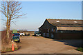
Brickhill Pastures
Farmhouse and adjoining buildings. The public footpath passes through the middle of the plot
Image: © Dennis simpson
Taken: 9 Mar 2008
0.11 miles
3
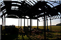
Derelict Barn, Brickhill Pastures
This is also featured in Image] and looks better from this angle.
Image: © Mark Anderson
Taken: 1 Jan 2010
0.14 miles
4
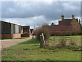
Blot on the landscape
Apparently derelict farm buildings.
Image: © Dennis simpson
Taken: 17 Feb 2008
0.15 miles
5
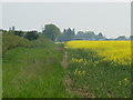
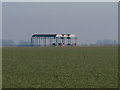
Field and Hedgerow
Rape crop in flower. The red blob in the middle of the screen is a bird scarer.
Image: © Dennis simpson
Taken: 11 May 2008
0.24 miles