IMAGES TAKEN NEAR TO
The Brache, BEDFORD, MK45 2DS
Introduction
This page details the photographs taken nearby to The Brache, MK45 2DS by members of the Geograph project.
The Geograph project started in 2005 with the aim of publishing, organising and preserving representative images for every square kilometre of Great Britain, Ireland and the Isle of Man.

There are currently over 7.5m images from over14,400 individuals and you can help contribute to the project by visiting https://www.geograph.org.uk
Image Map
Images are licensed for reuse under creativecommons.org/licenses/by-sa/2.0
Notes
- Clicking on the map will re-center to the selected point.
- The higher the marker number, the further away the image location is from the centre of the postcode.
Image Listing (15 Images Found)
Images are licensed for reuse under creativecommons.org/licenses/by-sa/2.0
Image
Details
Distance
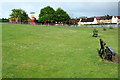
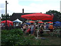
2
Benches looking down on the recreation field
Image: © Philip Jeffrey
Taken: 11 May 2013
0.12 miles
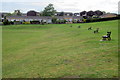
5
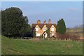
Farm house
The rock music coming from the house, broke the silence.
Image: © Dennis simpson
Taken: 16 Dec 2007
0.15 miles
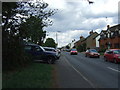
7
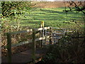
Double Whammy
Bridge, Turnstile, footpath sign - at least three geographic features in the one photo!
On the Greensand Ridge Walk just north of Maulden.
Image: © Dennis simpson
Taken: 6 Jan 2008
0.17 miles
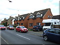
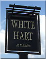
10

Morgan Classics
Three Morgans (count them) in the car park of The White Hart.
Image: © Burgess Von Thunen
Taken: 28 Apr 2013
0.21 miles