IMAGES TAKEN NEAR TO
The Knoll, BEDFORD, MK45 2DB
Introduction
This page details the photographs taken nearby to The Knoll, MK45 2DB by members of the Geograph project.
The Geograph project started in 2005 with the aim of publishing, organising and preserving representative images for every square kilometre of Great Britain, Ireland and the Isle of Man.

There are currently over 7.5m images from over14,400 individuals and you can help contribute to the project by visiting https://www.geograph.org.uk
Image Map
Images are licensed for reuse under creativecommons.org/licenses/by-sa/2.0
Notes
- Clicking on the map will re-center to the selected point.
- The higher the marker number, the further away the image location is from the centre of the postcode.
Image Listing (26 Images Found)
Images are licensed for reuse under creativecommons.org/licenses/by-sa/2.0
Image
Details
Distance
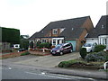
1
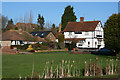
The Knoll, Maulden
Looking from Ampthill Road towards the Knoll and The George public house.
Image: © Mark Anderson
Taken: 1 Jan 2010
0.03 miles
3
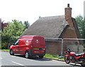
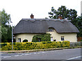
The Bothy
18th Century thatched cottage.
Image: © Jeff Tomlinson
Taken: 18 May 2014
0.07 miles
4
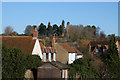
Rooftops, Maulden
Looking across towards Maulden Church
Image: © Mark Anderson
Taken: 1 Jan 2010
0.07 miles
5
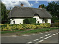
Willow End Cottage, Maulden, Beds
on the Ampthill Road.
Image: © Rodney Burton
Taken: 22 Jun 2006
0.08 miles
8
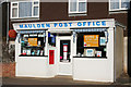
Maulden Post Office
A closer view of the postbox can be seen here: Image]
Image: © Mark Anderson
Taken: 1 Jan 2010
0.11 miles
9
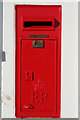
Elizabeth II Postbox, Maulden
Set into the wall of Maulden Post Office which can be seen here: Image]
Image: © Mark Anderson
Taken: 1 Jan 2010
0.11 miles
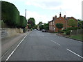
10
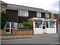
Post Office, Maulden, Beds
on the Ampthill Road.
Image: © Rodney Burton
Taken: 22 Jun 2006
0.11 miles