IMAGES TAKEN NEAR TO
Sharp Close, BEDFORD, MK45 2BZ
Introduction
This page details the photographs taken nearby to Sharp Close, MK45 2BZ by members of the Geograph project.
The Geograph project started in 2005 with the aim of publishing, organising and preserving representative images for every square kilometre of Great Britain, Ireland and the Isle of Man.

There are currently over 7.5m images from over14,400 individuals and you can help contribute to the project by visiting https://www.geograph.org.uk
Image Map
Images are licensed for reuse under creativecommons.org/licenses/by-sa/2.0
Notes
- Clicking on the map will re-center to the selected point.
- The higher the marker number, the further away the image location is from the centre of the postcode.
Image Listing (10 Images Found)
Images are licensed for reuse under creativecommons.org/licenses/by-sa/2.0
Image
Details
Distance
4
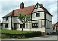
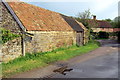
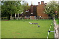
Black & White house, Hall End
A fine old timber-framed house on Clophill Road, Hall End near Maulden.
Image: © Rob Farrow
Taken: 18 May 2006
0.14 miles
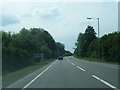
6
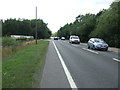
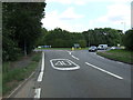
A507, Water End
Heading south west near the garden centre.
Image: © JThomas
Taken: 22 Aug 2015
0.22 miles
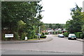
8
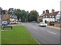
Clophill village green and High St, Beds
View towards the A6 with the Flying Horse pub on the corner.
Image: © Rodney Burton
Taken: 12 Oct 2005
0.25 miles
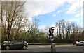
10
A507 approaching roundabout,Clophill
Heading east.
Image: © JThomas
Taken: 22 Aug 2015
0.25 miles