IMAGES TAKEN NEAR TO
The Meadows, BEDFORD, MK45 1XG
Introduction
This page details the photographs taken nearby to The Meadows, MK45 1XG by members of the Geograph project.
The Geograph project started in 2005 with the aim of publishing, organising and preserving representative images for every square kilometre of Great Britain, Ireland and the Isle of Man.

There are currently over 7.5m images from over14,400 individuals and you can help contribute to the project by visiting https://www.geograph.org.uk
Image Map
Images are licensed for reuse under creativecommons.org/licenses/by-sa/2.0
Notes
- Clicking on the map will re-center to the selected point.
- The higher the marker number, the further away the image location is from the centre of the postcode.
Image Listing (17 Images Found)
Images are licensed for reuse under creativecommons.org/licenses/by-sa/2.0
Image
Details
Distance
3
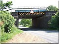
Froghall Road Bridge
Bridge No.154 carrying the railway over Froghall Road at Froghall near Flitwick.
Image: © Rob Farrow
Taken: 7 Jun 2006
0.14 miles
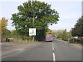
4
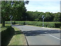
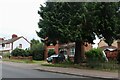
Froghall Road
Heading south west from Ampthill.
Image: © JThomas
Taken: 22 Aug 2015
0.15 miles
5
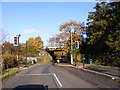
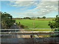
Railway Bridge
The view of the bridge over Froghall Road at Flitwick in Bedfordshire.
Image: © Gordon Griffiths
Taken: 11 Nov 2018
0.16 miles
6
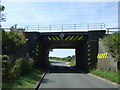
Low railway bridge crossing Froghall Road
Heading south west.
Image: © JThomas
Taken: 22 Aug 2015
0.16 miles
8
Froghall Road
From the railway bridge on the Midland Main Line.
Image: © Andrew Abbott
Taken: 17 Jun 2019
0.17 miles