IMAGES TAKEN NEAR TO
Roman Way, BEDFORD, MK45 1RP
Introduction
This page details the photographs taken nearby to Roman Way, MK45 1RP by members of the Geograph project.
The Geograph project started in 2005 with the aim of publishing, organising and preserving representative images for every square kilometre of Great Britain, Ireland and the Isle of Man.

There are currently over 7.5m images from over14,400 individuals and you can help contribute to the project by visiting https://www.geograph.org.uk
Image Map
Images are licensed for reuse under creativecommons.org/licenses/by-sa/2.0
Notes
- Clicking on the map will re-center to the selected point.
- The higher the marker number, the further away the image location is from the centre of the postcode.
Image Listing (4 Images Found)
Images are licensed for reuse under creativecommons.org/licenses/by-sa/2.0
Image
Details
Distance
1
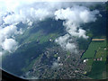
Flitwick from the air
Viewed from a Luton bound flight from Glasgow.
Image: © Thomas Nugent
Taken: 17 Jun 2012
0.13 miles
2
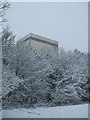
Factory in the snow
My place of work during the snowy period Feb 2009
Image: © Barry Ephgrave
Taken: 5 Feb 2009
0.17 miles
4
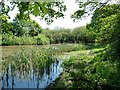
Pussy Pond
Pussy pond is named for the pussy willows which grow around the pond. It most likely started life as a sand, gravel or clay pit many years ago.
Image: © Paul Buckingham
Taken: 25 Apr 2011
0.22 miles