IMAGES TAKEN NEAR TO
Vicarage Hill, BEDFORD, MK45 1HZ
Introduction
This page details the photographs taken nearby to Vicarage Hill, MK45 1HZ by members of the Geograph project.
The Geograph project started in 2005 with the aim of publishing, organising and preserving representative images for every square kilometre of Great Britain, Ireland and the Isle of Man.

There are currently over 7.5m images from over14,400 individuals and you can help contribute to the project by visiting https://www.geograph.org.uk
Image Map
Images are licensed for reuse under creativecommons.org/licenses/by-sa/2.0
Notes
- Clicking on the map will re-center to the selected point.
- The higher the marker number, the further away the image location is from the centre of the postcode.
Image Listing (21 Images Found)
Images are licensed for reuse under creativecommons.org/licenses/by-sa/2.0
Image
Details
Distance
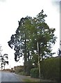
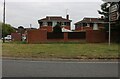
2
Vicarage Hill at the junction of the A5120
Image: © David Howard
Taken: 28 Jul 2016
0.08 miles
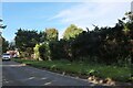
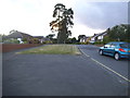
3

Vicarage Hill at the junction of the A5120
Image: © David Howard
Taken: 28 Jul 2016
0.09 miles

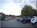
7
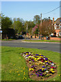
Dunstable Road, Flitwick
A flower bed enlivens the junction between Dunstable Road and Church Road in the southern part of this small Bedfordshire commuter town.
Image: © Stephen McKay
Taken: 27 Apr 2010
0.11 miles