IMAGES TAKEN NEAR TO
St. Marks Close, BEDFORD, MK45 1HG
Introduction
This page details the photographs taken nearby to St. Marks Close, MK45 1HG by members of the Geograph project.
The Geograph project started in 2005 with the aim of publishing, organising and preserving representative images for every square kilometre of Great Britain, Ireland and the Isle of Man.

There are currently over 7.5m images from over14,400 individuals and you can help contribute to the project by visiting https://www.geograph.org.uk
Image Map
Images are licensed for reuse under creativecommons.org/licenses/by-sa/2.0
Notes
- Clicking on the map will re-center to the selected point.
- The higher the marker number, the further away the image location is from the centre of the postcode.
Image Listing (7 Images Found)
Images are licensed for reuse under creativecommons.org/licenses/by-sa/2.0
Image
Details
Distance
1
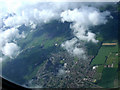
Flitwick from the air
Viewed from a Luton bound flight from Glasgow.
Image: © Thomas Nugent
Taken: 17 Jun 2012
0.06 miles
2
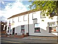
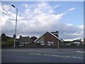
Haines and Watts accountants, Flitwick High Street
Their website is http://www.hwca.com/
Image: © David Howard
Taken: 28 Jul 2016
0.21 miles
3
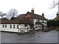
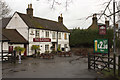
The Blackbirds P.H., Flitwick
This pub is beside the main road through the northern part of Flitwick. The inn sign above the door shows a large crown hovering above a pie with three blackbirds peeping out ... alluding of course to the nursery rhyme "sing a song of sixpence".
Image: © Rob Farrow
Taken: 22 Feb 2007
0.22 miles
5
The Blackbirds Public House, Flitwick
Image: © Mark Anderson
Taken: 29 Mar 2015
0.23 miles
7
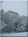
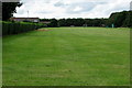
Factory in the snow
My place of work during the snowy period Feb 2009
Image: © Barry Ephgrave
Taken: 5 Feb 2009
0.25 miles