IMAGES TAKEN NEAR TO
Easton Road, BEDFORD, MK45 1HA
Introduction
This page details the photographs taken nearby to Easton Road, MK45 1HA by members of the Geograph project.
The Geograph project started in 2005 with the aim of publishing, organising and preserving representative images for every square kilometre of Great Britain, Ireland and the Isle of Man.

There are currently over 7.5m images from over14,400 individuals and you can help contribute to the project by visiting https://www.geograph.org.uk
Image Map
Images are licensed for reuse under creativecommons.org/licenses/by-sa/2.0
Notes
- Clicking on the map will re-center to the selected point.
- The higher the marker number, the further away the image location is from the centre of the postcode.
Image Listing (41 Images Found)
Images are licensed for reuse under creativecommons.org/licenses/by-sa/2.0
Image
Details
Distance
2
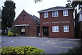
Flitwick Baptist Church
Flitwick Baptist Church taken in the early hours.
Image: © Barry Ephgrave
Taken: 10 Oct 2010
0.10 miles
8
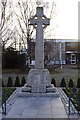
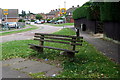
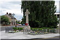
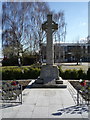
Flitwick War Memorial
Flitwick War Memorial - Wreaths did not last the winter.
Image: © Barry Ephgrave
Taken: 2 Jan 2011
0.18 miles
9
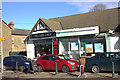
The Cafe Latte, Flitwick
And a very nice cafe it is too.
Image: © Robert Eva
Taken: 7 Feb 2018
0.19 miles
10
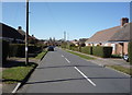
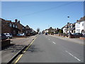
Hatfield Road, Flitwick
Looking west from Maulden Road.
Image: © JThomas
Taken: 25 Mar 2016
0.19 miles