IMAGES TAKEN NEAR TO
Minden Close, BEDFORD, MK45 1FD
Introduction
This page details the photographs taken nearby to Minden Close, MK45 1FD by members of the Geograph project.
The Geograph project started in 2005 with the aim of publishing, organising and preserving representative images for every square kilometre of Great Britain, Ireland and the Isle of Man.

There are currently over 7.5m images from over14,400 individuals and you can help contribute to the project by visiting https://www.geograph.org.uk
Image Map
Images are licensed for reuse under creativecommons.org/licenses/by-sa/2.0
Notes
- Clicking on the map will re-center to the selected point.
- The higher the marker number, the further away the image location is from the centre of the postcode.
Image Listing (7 Images Found)
Images are licensed for reuse under creativecommons.org/licenses/by-sa/2.0
Image
Details
Distance
5
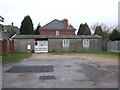
St. Andrew's Church, Flitwick
It has to be said, I've photographed prettier churches. This prefab is one of two places of worship on the same road, one either side of the railway bridge seen in Image]
I wonder what Pevsner would have made of this stunning bit of architecture; the concrete slab walls, concrete roof, plate glass windows with broad white fames and grey plastic drainpipes. The unfeatured oblong shape cleverly complemented by the obtrusive white meter cupboard not quite perpendicular to the rest of the structure. The whole ensemble completed by a row of three sheds. A perfect example of 1960s architecture, its English Heritage listing is surely a formality.
Image: © Rob Farrow
Taken: 22 Feb 2007
0.18 miles
6
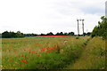
Poppy fields
Field of poppies in the distance and to the fore
Image: © Barry Ephgrave
Taken: 19 Jun 2010
0.19 miles
7
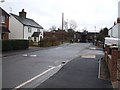
Windmill Road, Flitwick
A view roughly southwestward down Windmill Road in Flitwick showing the railway bridge. This photo taken from the pavement by Image]
Image: © Rob Farrow
Taken: 22 Feb 2007
0.23 miles