IMAGES TAKEN NEAR TO
Steppingley Road, BEDFORD, MK45 1AH
Introduction
This page details the photographs taken nearby to Steppingley Road, MK45 1AH by members of the Geograph project.
The Geograph project started in 2005 with the aim of publishing, organising and preserving representative images for every square kilometre of Great Britain, Ireland and the Isle of Man.

There are currently over 7.5m images from over14,400 individuals and you can help contribute to the project by visiting https://www.geograph.org.uk
Image Map
Images are licensed for reuse under creativecommons.org/licenses/by-sa/2.0
Notes
- Clicking on the map will re-center to the selected point.
- The higher the marker number, the further away the image location is from the centre of the postcode.
Image Listing (6 Images Found)
Images are licensed for reuse under creativecommons.org/licenses/by-sa/2.0
Image
Details
Distance
2
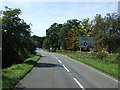
Approaching roundabout on Froghall Road
Near Steppingley Hospital.
Image: © JThomas
Taken: 22 Aug 2015
0.13 miles
3
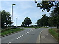
Roundabout on Froghall Road
Near Steppingley Hospital.
Image: © JThomas
Taken: 22 Aug 2015
0.13 miles
4
Steppingley Hospital
Small hospital and nursing home.
Image: © JThomas
Taken: 22 Aug 2015
0.15 miles
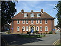
5
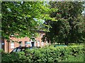
Steppingley Hospital
This little hospital and nursing home is on the crossroads of Froghall Road and Steppingley Road. It is quite an unusual location for a hospital being a considerable distance from any large town, and has a look of the old Cottage Hospitals about it.
Image: © Rob Farrow
Taken: 7 Jun 2006
0.17 miles
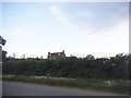
6
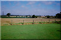
Fields behind Steppingley Hospital, 1988
The land in the foreground now has buildings and a car park.
Image: © Mark Anderson
Taken: Unknown
0.20 miles