IMAGES TAKEN NEAR TO
Abbis Close, BEDFORD, MK45 1AF
Introduction
This page details the photographs taken nearby to Abbis Close, MK45 1AF by members of the Geograph project.
The Geograph project started in 2005 with the aim of publishing, organising and preserving representative images for every square kilometre of Great Britain, Ireland and the Isle of Man.

There are currently over 7.5m images from over14,400 individuals and you can help contribute to the project by visiting https://www.geograph.org.uk
Image Map
Images are licensed for reuse under creativecommons.org/licenses/by-sa/2.0
Notes
- Clicking on the map will re-center to the selected point.
- The higher the marker number, the further away the image location is from the centre of the postcode.
Image Listing (5 Images Found)
Images are licensed for reuse under creativecommons.org/licenses/by-sa/2.0
Image
Details
Distance
1
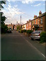
Chapel Road
Workers cottages in Flitwick.
Image: © Burgess Von Thunen
Taken: 11 Jun 2011
0.14 miles
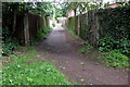
4
Windmill Road, Flitwick
A view roughly southwestward down Windmill Road in Flitwick showing the railway bridge. This photo taken from the pavement by Image]
Image: © Rob Farrow
Taken: 22 Feb 2007
0.23 miles
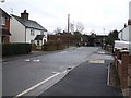
5
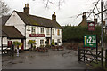
The Blackbirds Public House, Flitwick
Image: © Mark Anderson
Taken: 29 Mar 2015
0.25 miles