IMAGES TAKEN NEAR TO
Twain Way, MK4 4SQ
Introduction
This page details the photographs taken nearby to Twain Way, MK4 4SQ by members of the Geograph project.
The Geograph project started in 2005 with the aim of publishing, organising and preserving representative images for every square kilometre of Great Britain, Ireland and the Isle of Man.

There are currently over 7.5m images from over14,400 individuals and you can help contribute to the project by visiting https://www.geograph.org.uk
Image Map
Images are licensed for reuse under creativecommons.org/licenses/by-sa/2.0
Notes
- Clicking on the map will re-center to the selected point.
- The higher the marker number, the further away the image location is from the centre of the postcode.
Image Listing (14 Images Found)
Images are licensed for reuse under creativecommons.org/licenses/by-sa/2.0
Image
Details
Distance
1
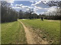
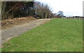
Bridleway heading to Bottle Dump Roundabout
Bridleway from Tattenhoe Bare Farm heading to Bottle Dump Roundabout
Image: © Shaun Ferguson
Taken: 2 May 2014
0.12 miles
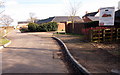
3
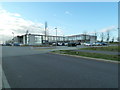
Priory Rise School
Opened in September 2008 to serve the communities of Tattenhoe Park and South Kingsmead.
Image: © Malcolm Campbell
Taken: 23 Jan 2012
0.16 miles
5
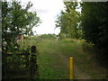
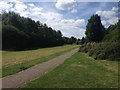
Midshires Way
A horserider on the midshires way, heading south towards the Bottle Dump Roundabout.
Image: © Mr Biz
Taken: 9 Aug 2006
0.18 miles

8
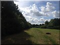
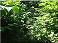
New housing on the edge of Milton Keynes
Image: © Philip Jeffrey
Taken: 24 Feb 2012
0.22 miles