IMAGES TAKEN NEAR TO
Crathes Gardens, MILTON KEYNES, MK4 4JX
Introduction
This page details the photographs taken nearby to Crathes Gardens, MK4 4JX by members of the Geograph project.
The Geograph project started in 2005 with the aim of publishing, organising and preserving representative images for every square kilometre of Great Britain, Ireland and the Isle of Man.

There are currently over 7.5m images from over14,400 individuals and you can help contribute to the project by visiting https://www.geograph.org.uk
Image Map (Loading...)


Getting Data...Please wait
Leaflet Map data © OpenStreetMap
Images are licensed for reuse under creativecommons.org/licenses/by-sa/2.0
Notes
- Clicking on the map will re-center to the selected point.
- The higher the marker number, the further away the image location is from the centre of the postcode.
Image Listing (5 Images Found)
Images are licensed for reuse under creativecommons.org/licenses/by-sa/2.0
Image
Details
Distance
1
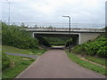
Path around the Whitney Roundabout
Path around the Whitney Roundabout heading under Snelshall Street
Image: © Shaun Ferguson
Taken: 2 May 2014
0.19 miles
2
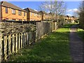
Wattle fence on the path to Westcroft centre
Image: © Philip Jeffrey
Taken: 29 Mar 2020
0.19 miles
4
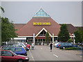
Morrisons Supermarket
Part of the Westcroft Shopping Area, was originally a Safeway store.
Image: © Mr Biz
Taken: 27 Jul 2006
0.22 miles