IMAGES TAKEN NEAR TO
Goldney Court, MILTON KEYNES, MK4 4EX
Introduction
This page details the photographs taken nearby to Goldney Court, MK4 4EX by members of the Geograph project.
The Geograph project started in 2005 with the aim of publishing, organising and preserving representative images for every square kilometre of Great Britain, Ireland and the Isle of Man.

There are currently over 7.5m images from over14,400 individuals and you can help contribute to the project by visiting https://www.geograph.org.uk
Image Map
Images are licensed for reuse under creativecommons.org/licenses/by-sa/2.0
Notes
- Clicking on the map will re-center to the selected point.
- The higher the marker number, the further away the image location is from the centre of the postcode.
Image Listing (10 Images Found)
Images are licensed for reuse under creativecommons.org/licenses/by-sa/2.0
Image
Details
Distance
1
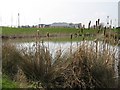
No need to rush
Tranquil pond near the Tesco Express at Kingsmead development, shows Oxley Park Primary School in the background.
Image: © Malcolm Campbell
Taken: 5 Mar 2009
0.13 miles

3
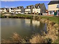
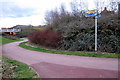
View from
Taken from Powis Lane looking towards Kingsoak a new development at Oxley Park
Image: © Malcolm Campbell
Taken: 5 Mar 2009
0.15 miles
6
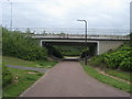
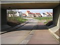
Path around the Whitney Roundabout
Path around the Whitney Roundabout heading under Snelshall Street
Image: © Shaun Ferguson
Taken: 2 May 2014
0.18 miles
7
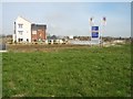
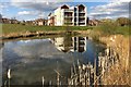
Oxley Gate
George Wimpey still building away at Oxley Gate despite the economic doom and gloom.
Image: © Malcolm Campbell
Taken: 5 Mar 2009
0.18 miles
9
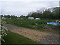
Powis Lane allotments
Off Childs Way the Powis Lane allotments
Image: © Shaun Ferguson
Taken: 2 May 2014
0.22 miles
10
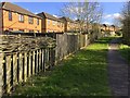
Wattle fence on the path to Westcroft centre
Image: © Philip Jeffrey
Taken: 29 Mar 2020
0.24 miles