IMAGES TAKEN NEAR TO
Steinbeck Crescent, MILTON KEYNES, MK4 4AE
Introduction
This page details the photographs taken nearby to Steinbeck Crescent, MK4 4AE by members of the Geograph project.
The Geograph project started in 2005 with the aim of publishing, organising and preserving representative images for every square kilometre of Great Britain, Ireland and the Isle of Man.

There are currently over 7.5m images from over14,400 individuals and you can help contribute to the project by visiting https://www.geograph.org.uk
Image Map
Images are licensed for reuse under creativecommons.org/licenses/by-sa/2.0
Notes
- Clicking on the map will re-center to the selected point.
- The higher the marker number, the further away the image location is from the centre of the postcode.
Image Listing (25 Images Found)
Images are licensed for reuse under creativecommons.org/licenses/by-sa/2.0
Image
Details
Distance
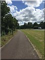
1
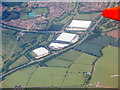
Warehouses at Snelshall
On the outskirts of Bletchley, on the A421.
Image: © M J Richardson
Taken: 26 Jun 2015
0.05 miles
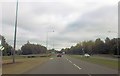
2
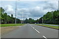
A421 Standing Way, Milton Keynes, heading east
Or H8 under the Milton Keynes road grid numbering system.
Image: © Robin Webster
Taken: 9 Jun 2019
0.08 miles
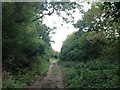
7
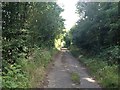
Course of the old B4034 into Bletchley
Image: © Philip Jeffrey
Taken: 9 Apr 2020
0.11 miles

9
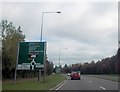
Warning signs for Tattenhoe roundabout from A421
Image: © John Firth
Taken: 22 Sep 2013
0.16 miles
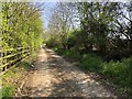
10
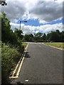
A421 from Steinbeck Crescent
This is the western entrance to Steinbeck Crescent
Image: © John Firth
Taken: 22 Sep 2013
0.16 miles